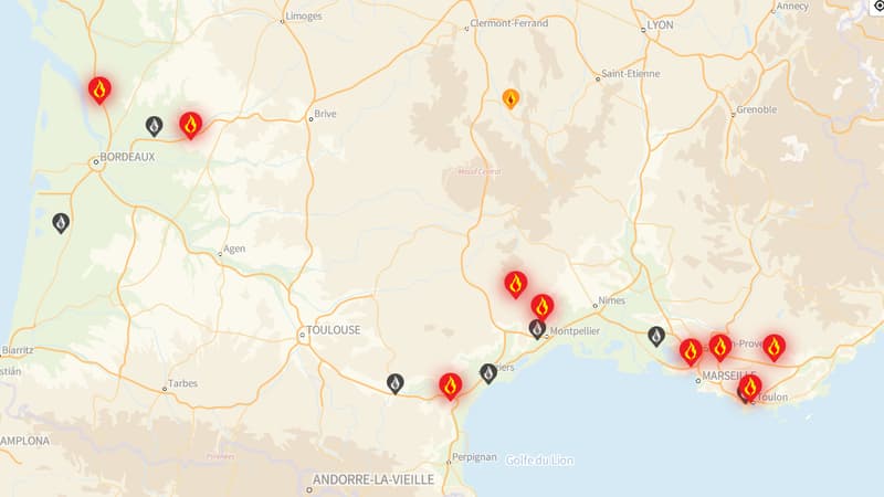
Near Narbonne, in Marseille, in Saint-Martin-Du-Var … fire exits have multiplied while temperatures increased dramatically at the beginning of the summer of 2025.
Some are controlled, but others are still underway and are even in “mode of attack”, that is, firefighters still fight to circumscribe them. Therefore, this requires adapting, sometimes in real time, since fires can quickly evolve and weigh a risk of people’s safety.
There are several tools to protect fires and learn about the situation.
“Forest Firos” and “Fire Hunter” applications
The community of forests and natural spaces “that speak in French offers in the outputs of fire in real time and its current situation thanks to a detailed map based on data from the National Forest Office (ONF).
The application (iOS and Android) can send alerts in case of danger. The information is also available on the Internet. In addition, you can also participate to indicate whether a fire has been under control or if it is a false alert. You can also access a surveillance card for walkers.
For the inhabitants of Bouche-Du-Rhone and Vaucluse, there is also a more specific application, adapted to the local level: “Fire Chaser”. It is accessible in iOS and Android.
The Google Maps application
Since the summer of 2024, Google has been offering through its application of cartography, Google Maps, to see the fires in progress in the territory. This results in an area highlighted in red when looking for the terms “fire” or “forest fires” in the application, or an alert if it makes a route that passes through these areas.
However, keep in mind that map data is not necessarily very reactive compared to “forest fires.”
Another possible solution: Waze. For motorists, a specific alert of fires on the road allows you to know, when you take the steering wheel, that runs the risk of crossing a danger zone.
Smart Telephone alerts
In case of serious or imminent danger, your smartphone can also allow the authorities to warn you. An alert, similar to that of a terrorist or organic risk, may sound very strongly, without taking into account the passage in silent mode, even if it does not have a network.
This is the FR-ALErt system, which was deployed in June 2022. As the government information site writes, “FR-ALErt makes it possible to notice in real time anyone who has a mobile phone of their presence in an area of danger to inform you about the behavior to adopt to protect yourself.”
So remember to activate these alerts, by default, especially if it moves in areas at risk.
Finally, it is also advisable to direct the ONF site to find out the climatic conditions and the risks of fire in progress (they are very high in southern France), before walking or walking through forests and mountain range.
Source: BFM TV


