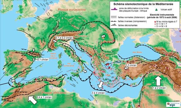
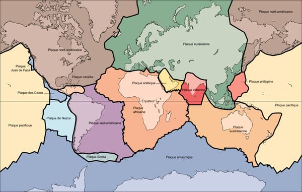
How to explain the violence of the earthquakes that occurred on Monday in Turkey in Syria, whose provisional balance exceeds 5,000 deaths? One of the reasons is the geographical location of this territory. In fact, Turkey lies between two tectonic plates, on the East Anatolian Fault, a seismic zone.
“When you look at a seismic hazard map, you realize that some areas of the world are much more exposed than others,” writes the CNRS. “This geographical distribution can be explained in a simple way: the closer a fault site is (border between two tectonic plates), the greater its danger.”

The puzzle of 53 tectonic plates that make up the Earth’s surface is far from over.
The Earth “is animated by slow but permanent movements”, emphasizes the IRSN (Institute for Radiological Protection and Nuclear Safety) and “it is these movements between the lithospheric plates that constitute the main force at the origin of earthquakes”.
Why do these plates cause earthquakes?
With these incessant movements, the tectonic plates deform slowly and not smoothly, they rub against each other. “Rocks behave like a spring that is compressed, deformed: elastic energy accumulates,” details the IRSN. And when their resistance threshold is reached, “they suddenly give way allowing tectonic plates to slide past each other on either side of a fault line.”
Consequently, “the energy accumulated over time is released in a few seconds in the form of heat and vibrations. These vibrations then propagate step by step towards the surface: the Earth trembles”.

Thus, Monday’s earthquake was caused by a northward movement of the Arabian tectonic plate that “advances over Turkey,” Roger Musson, a research associate at the British Geological Survey, told AFP. When the stress becomes too strong, the plate suddenly advances and “the release of this movement produces a large earthquake, like the one we had on Monday.”
Where do the strongest earthquakes occur?
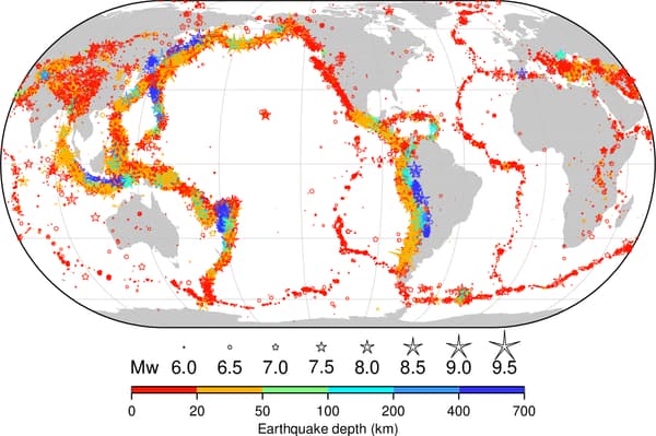
The largest magnitude earthquakes occur at so-called subduction zones, where one tectonic plate plunges beneath another.
“There we find the most violent earthquakes and also the deadliest due to their geographical location, often close to areas with a high population density,” explains the museum of seismology of the university of strasbourgciting Chile, Japan and even Mexico.

It is also indicated that “the epicenters of recent earthquakes” are located mainly in “the peripacific zone (periphery of the Pacific) and the loop of the Antilles that represent 80% of the annual seismic activity”.
The mid-oceanic ridge zones – submarine volcanic mountains – are also of particular concern, as well as an “area situated on the border of the Eurasian and African continents, from the Azores to Java”.
The least affected center of tectonic plates
Between these faults, the central surface of the plates is much less affected by earthquakes. “However, rigid plates are capable of transmitting the forces they experience at the level of the contact zones over a distance,” stresses the IRSN. “This is how we also observe earthquakes far from plate boundaries, such as in the east-central United States, in Australia, or in metropolitan France.”
However, these earthquakes are less strong and fewer in number than those observed at the fault level.
It should also be noted that the high magnitude of an earthquake does not necessarily predict the material damage it will cause. “Thus, the magnitude 7.3 earthquake that took place in February 2021 off Fukushima injured 114 people. By comparison, the 7.2 magnitude earthquake that devastated Haiti in August 2021 caused more than 2,200 deaths and 12,000 injuries,” recalls the CNRS.
The research center thus underlines the importance of establishing seismic standards, an early warning system and preventive measures to limit the impact of these disasters, which we still do not know how to predict.
Source: BFM TV

