Considerable damage. Powerful Hurricane Ian swept through Florida on Wednesday, its high winds and torrential rain already causing “catastrophic” flooding and widespread power outages.
Slightly out of the hurricane’s path, near the Keys archipelago, poor conditions caused a boat carrying migrants to capsize, and the Coast Guard was still searching for 20 people, with three rescued and four others managing to swim to shore.
With winds of up to 185 km / h, Ian made landfall on the coast of Cayo Costa, in the southwest of the state, at 3:05 p.m. local time (7:05 p.m. GMT), according to the National Hurricane Center Americans (CNH). The hurricane was causing “catastrophic” flooding, the center said.
Previously rated at category 4 out of 5 on the Saffir-Simpson scale, Ian is now at category 3 but is still destructive, according to this same source.
Darkness
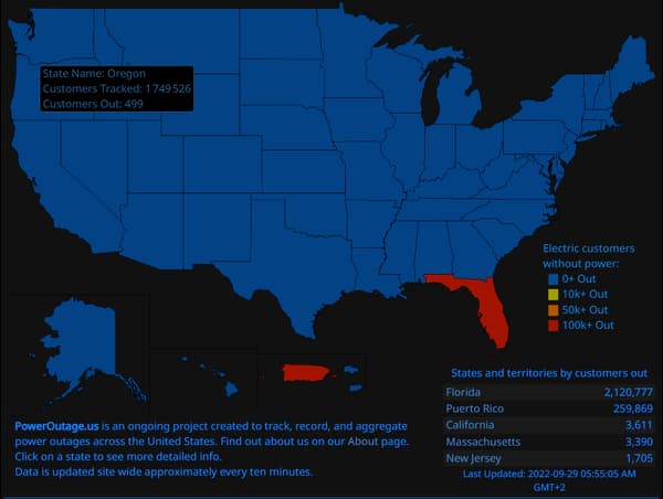
About 2 million homes were left without electricity on Wednesday night in Florida, mainly around the path of the hurricane, according to the specialized site PowerOutage.
Several counties near where Ian made landfall were nearly without power, according to the site.

The town of Punta Gorda was thus plunged into darkness. At night, only a few buildings equipped with generators remained lit, the only sounds around were the roar of the wind and the pouring rain.
A few hours earlier, the city had experienced a brief respite when it found itself in the eye of the hurricane. But the showers and rain returned with more force, knocking down traffic signs and taking away pieces of roofs and tree branches.
In Naples, in southwestern Florida, images from the MSNBC channel showed completely flooded streets and cars floating in the current.
In the city of Fort Myers, the flooding was so severe that some neighborhoods resembled lakes.
The flooding could sometimes exceed 3 meters, announced Wednesday night the governor of the state, Ron DeSantis.
The weather phenomenon should move inland during the day and emerge over the western Atlantic on Thursday night, according to the NHC.
Hurricane Ian is expected to weaken as it passes inland but could still cause significant damage as it reaches eastern Florida, he said.
“Very dangerous”
Governor Ron DeSantis said Wednesday night that it would likely be “one of the five strongest hurricanes to hit Florida.”
“This is a storm that will be talked about for many years,” NWS Director Ken Graham told a news conference.
Fema (the federal disaster relief agency) director Deanne Criswell said Ian would remain a “very dangerous” storm for “days to come.”
Intensification
Hurricane Ian hit Cuba on Tuesday, killing two people and plunging the island into darkness.
As the surface of the oceans warms, the frequency of more intense hurricanes, with stronger winds and more precipitation, increases, but not the total number of hurricanes.
According to Gary Lackmann, a professor of atmospheric sciences at North Carolina State University in the United States, several studies have shown a “possible link” between climate change and a phenomenon known as “rapid intensification” – when a relatively weak tropical climate the storm strengthens to a Category 3 or greater hurricane within 24 hours, as was the case with Ian.
“There is still a consensus that there will be fewer storms in the future, but the bigger ones will be more intense,” the scientist told AFP.
Source: BFM TV

