On Wednesday, Hurricane Ian swept through Florida, gusting close to 250 km/h, narrowly losing its Category 5 rating. Overnight, it caused significant damage in this state in the southeastern United States, with no information yet. of a clear evaluation. The evacuation of 2.5 million people was ordered.
But since hovering over land, Ian and his gusts have faded. The cyclone was feeding off warm water temperatures in the Gulf of Mexico to gain strength. So much so that the National Hurricane Center downgraded it to a tropical storm.
Torrential rains and flash floods
This is not the end of the ordeal for Americans living on the East Coast, who now have to deal with torrential rains.
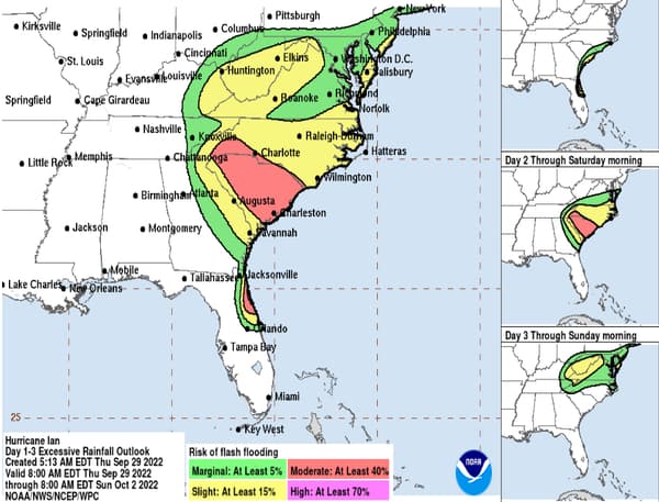
Gradually crossing Florida from southeast to northeast, Ian will head toward North Carolina and South Carolina, where the risk of flash flooding is very high.

As the National Hurricane Center map above shows, the risk of flooding is significant for the next few days. This Thursday it is the north coast of Florida that is concerned, before the threat spreads to all of South Carolina on Friday, placed in a state of emergency. North Carolina, Virginia, and West Virginia are also affected, to a lesser extent.
A shark in the streets
A worrying situation, but that was to be expected. When a hurricane makes landfall, it is not so much the damage caused by the gusts that worries public authorities, but that of the flooding.
Likewise, the sea level is bound to rise. Also according to the National Hurricane Center, along the coasts of Georgia, South Carolina and North Carolina, the Atlantic Ocean should gain up to 1.5 meters. A dynamic resulting in particular from the torrential rains caused by Ian. Another 200mm of rain is expected in the next few hours.
A sign of this rising waters, which suggests the worst when it comes time to take stock, are the images that were shot in Fort Myers. In this southeastern Florida town, a shark was filmed swimming through submerged streets.
Source: BFM TV

